NIRD Model
The National Infrastructure Resilience Demonstrator project, or NIRD for short, was a Building a Secure and Resilient World’ (BSRW) funded project. Read on to find out more about the model produced from this project from the creator’s viewpoint.
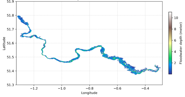
 Flood event along the Thames catchment in England.
Description of the model
The National Infrastructure Resilience Demonstrator (NIRD) is a national-scale modelling framework for assessing infrastructure network resilience to extreme flooding. NIRD is currently applied to the road network for Great Britain, providing a process-based model capable of representing large-scale traffic flows and their disruptions under flood scenarios. The GB application involves using road network data from Ordnance Survey (OS) and journey-to-work census statistics from Office of National Statistics (ONS) for England and Wales and National Record for Scotland (NRS). The model application has been built using Great Britain data, but the framework and underlying codes are generalisable globally.
What does the model do
NIRD was developed to evaluate flooding impacts on road transport, with particular application on capturing journey-to-work passenger flow patterns across GB. The model first represents GB-scale travel patterns along the physical road network, capturing congestion and capacity limitations of the network. The modelled flow volumes (i.e. number of trips) along roads are found to be in good agreement with observed statistics on daily traffic counts released by the UK Department for Transport (DfT). Next the model captures the interactions between extreme flood events and the road network, by estimating three metrics: (1) the vulnerability of road assets in terms of the direct damage costs (for repairing road assets); (2) the criticality of routes in terms of the indirect rerouting costs (due to flood induced road closures and speed restrictions); and (3) the impacts on commuters in terms of the number of flow isolations (from to inability to travel due to road closures).
The model accounts for uncertainties in asset vulnerability and rates of recovery from flood events, which influence the values of the above metrics and highlight the importance of prioritising resilience by reducing direct hazard impacts and improving recovery of critical assets in the network.
Why was the model made
The motivation for the model comes from the need outlined by the UK National Infrastructure Commission (NIC), infrastructure operators and regulators to develop data and tools for stress-testing networks to extreme hazards scenarios to understand systemic impacts of failures. The UK’s transport systems are increasingly exposed to extreme flood events that severely damage the infrastructure assets and disrupt mobility. In existing post-disaster estimates from UK government agencies there is a lot of uncertainty and lack of information on quantitative estimations of road disruption impacts, which is challenging.
NIRD responds to the above national-scale needs and provides a model and data to undertake large-scale flood failure and disruption analysis. First, it couples extreme flood scenarios with transport network simulations, integrating large spatial and temporal datasets. Second, it quantifies risk and resilience outcomes through metrics that comprehensively evaluate the capacity of the transport system to absorb and recover from flood impacts. All of this is supported by the high performance computing capabilities provided by DAFNI, which is crucial for the success of such research.
What was envisioned for the model
The vision for NIRD was to deliver a large-scale spatially detailed model for infrastructure network risks and resilience assessment. Hence, the current model was developed to model passenger flows and stress-test road resilience under flood disruptions at a national-scale. The model was also developed in a way that could be easily adapted to different spatial scales and hazard contexts. The team envisioned a model that could address the knowledge gap in estimating systemic impacts of road network failures and provide more robust estimates of post-disaster flood direct and indirect costs to inform policy makers.
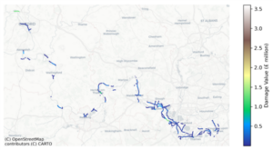
Direct damages estimated at road asset level.
How is the model intended to be used
The first use case of NIRD has been to assess historic flood losses attributed to Great Britain’s road network. The model was stress-tested against 17 known very large historical flood events from 1953-2024 that occurred in GB. These flood events were created by JBA Risk Management, who are world-leading experts in flood hazard modelling. The results of the analysis showed the heterogeneity of direct and indirect losses across different events and captured the range of uncertainties associated with these events. This analysis is currently under review in a journal, and a preprint is available here https://papers.ssrn.com/sol3/papers.cfm?abstract_id=5312777.
The model is being currently adapted into various projects to expand its scope and test its robustness to different case-studies. These project include: (1) UKRI-Defra-funded MACC Hub project (https://macchub.co.uk/) to work together with another DAFNI supported model OpenCLIM (https://www.dafni.ac.uk/openclim/) to estimate risks to transport network under future population and climate change scenario; (2) A EU-Horizon funded MIRACA project (https://miraca-project.eu/) on multi-hazard infrastructure resilience at the European scale.
Contact:
Yue Li, yue.li@ouce.ox.ac.uk