SCQUAIR Model
The SCQUAIR (Small Changes, QUANT and AI Resilience) project simulates the pattern of land use and transportation for England, Scotland and Wales, running myriad simulations to identify the impact of new jobs, in terms of where people live and how they travel there.
The underlying spatial interaction model is called QUANT, developed by Professor Michael Batty of UCL, and runs very rapidly in a web‑based environment. Read on to find out more about the model produced from this project from the creator’s viewpoint.
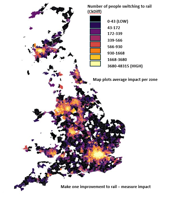
Map from the DAFNI platform showing the number of people switching to rail.
Description of the model
QUANT is a spatial interaction, or gravity mode, of travel to work in England, Scotland and Wales. The raw data is based on Middle Layer Super Output Area (MSOA), along with the travel to workflows from the 2011 Census, which contains around 20 million workers. In addition to this, travel costs between zones are computed from network shortest path time on the road network, bus network and the rail network. Road times come from the road speed limits and time taken to drive the shortest path in terms of time. The bus and rail networks are built from the published timetables with time between nodes taken as the weight of the network when computing shortest paths.
What does the model do
It can take a graphml file containing changes to the road, bus or rail network, plus any changes to employment which it then uses to predict where people will want to live in order to get to the jobs. Calibration fits three beta parameters to the flow and network cost data in order to fit the average travel time for each mode. There is one beta for road, bus and rail. These do not change, so can be passed directly into the QUANT model run to save having to calibrate for every scenario that gets run. In addition to calibration, there are two basic ways of running QUANT: run batches of computer generated scenarios with aggregate impacts, or run a single scenario with impacts generated for every zone which can then be plotted on a map.
QUANT is built at the level of MSOA zones for England and Wales, and Intermediate Zones (IZ) for Scotland. This results in 8436 zones in the model. Each matrix for flows or shortest path costs is 8435×8345 elements.
Why was the model made
The reason for running QUANT is to build a scenario based on changing the number of jobs in a zone, or the travel time between zones on any of the modes. For example, QUANT can be used to run a Heathrow 3rd runway scenario to predict where people will want to live in order to commute to the new jobs offered by the airport, or it can also be used to run a Crossrail or High Speed 2 scenario, where travel times between zones are changed due to new infrastructure.
What was envisioned for the model
We envisioned a web based model that would run in real time and allow users to explore the results of changes that they make to the transport system or employment.
How is the model intended to be used
Predicting the results of large scale transport projects in the UK.
Contact:
Richard Milton, richard.milton@ucl.ac.uk